DataEire
Access expertly curated datasets built for precision, performance, and real-world impact. From market intelligence to demographic trends, get the data you need to move faster and make smarter decisions.
4.6 /5 - from 12k reviews
Datapoints published
0
available across industries
Monthly downloads
0
by analysts and developers
Data freshness
0
datasets updated within 30 days
Multi-Platform Compatibility
Our datasets are formatted for seamless use in Excel, MySQL, PostgreSQL, SQL Server, and other leading platforms—making integration fast and frictionless.
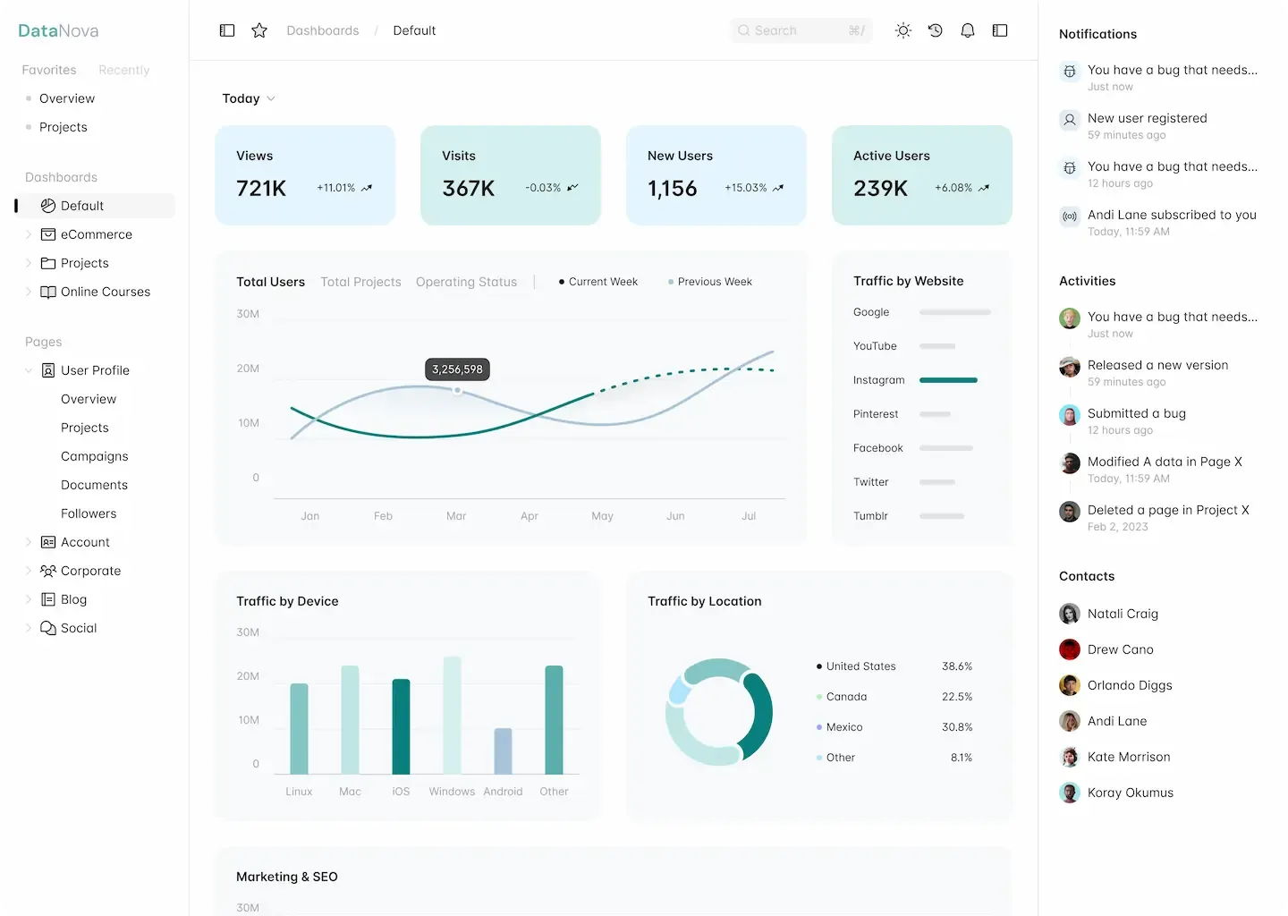
DataEire's Versatile Dataset Platform
Explore how DataEire delivers structured datasets—covering towns, routing files, postcodes, medical centers, and more—ready for integration with Excel, MySQL, PostgreSQL, SQL Server, and other analytics environments.
Seamless Integration, Local and Global
Whether you're working with regional datasets or global platforms, our formats are built for smooth integration. Designed to adapt to your environment, our data flows effortlessly into your existing tools and workflows.
Extensive Dataset Library
Choose from 50+ dataset types including towns, routing files, postcodes, and medical centers—ideal for logistics, planning, and public services.

Optimized for Analysis
Our datasets are clean, structured, and analysis-ready—perfect for mapping, forecasting, segmentation, and infrastructure planning across industries.
And more...
- Works seamlessly with Excel, MySQL, PostgreSQL, SQL Server, and cloud tools like Google Sheets
- Custom datasets available by region, format, or granularity
- Ideal for logistics, healthcare, urban planning, and public sector applications


Transform Raw Data into Strategic Insight
DataEire delivers clean, structured datasets—from towns and routing files to postcodes and medical centers—ready for integration with Excel, Smysl, PostgreSQL, SQL Server, and more. Use our data to uncover patterns, support planning, and make confident decisions across industries.
Access structured datasets optimized for Excel, SQL, GIS, and cloud platforms.
Identify trends and patterns using clean geographic and infrastructure data.
Use our datasets to build dashboards, reports, and decision tools tailored to your needs.
Why Choose DataEire?
Unlock the power of precision data with DataEire. Whether you're building location-based services, optimizing logistics, or enhancing public sector tools, our curated datasets—covering towns, routing files, postcodes, medical centers, and more—give you the reliable foundation you need to innovate with confidence.
From developers and analysts to government agencies and startups, DataEire makes geographic and infrastructural data easy to access and integrate. Our datasets are structured for usability, so you can go from raw data to actionable insights—fast.
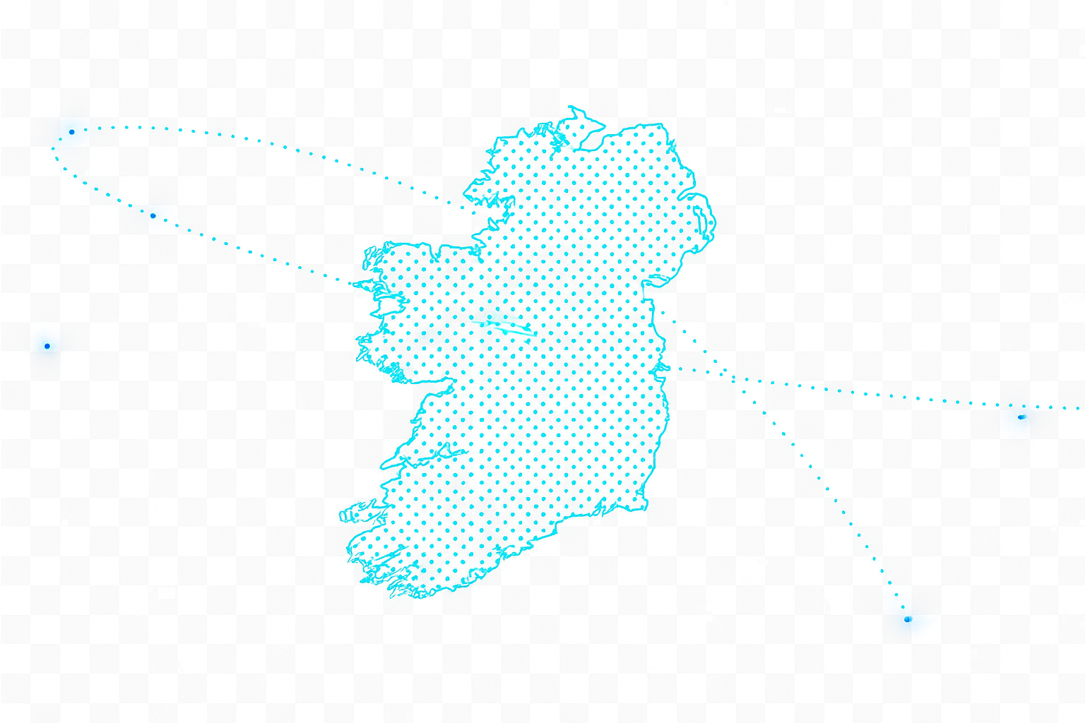
Our datasets are built around Ireland’s unique geography, infrastructure, and public services—from townlands and routing files to HSE medical centers and Eircode mapping.
No need to overhaul your workflow. DataEire’s datasets plug directly into your existing tools—Excel, GIS platforms, databases—so you can enrich your systems without disruption. It’s data that works where you work.
Stop Wasting Time Assembling Data.
Get instant access with DataEire.
Our ready-to-use datasets eliminate the hours of collection, cleaning, and formatting. Spend your time analyzing insights — not building spreadsheets.
Explore Datasets